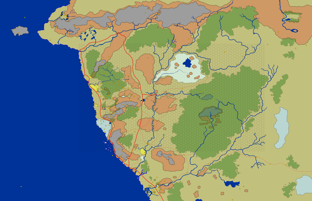
I'm the sort of DM that tends to overprepare. I wanted to know absolutely everything that can be known about all the places around Phandalin, with Neverwinter Woods, Sword Mountains.
I created the map in Inkscape so that I can do modifications easily in vector format. I can zoom in on regions of interest and add more details. I can add smaller streams, lakes, forest groves and paths that would not show up on a map for a larger region. There are also differences between official maps and changes over time.
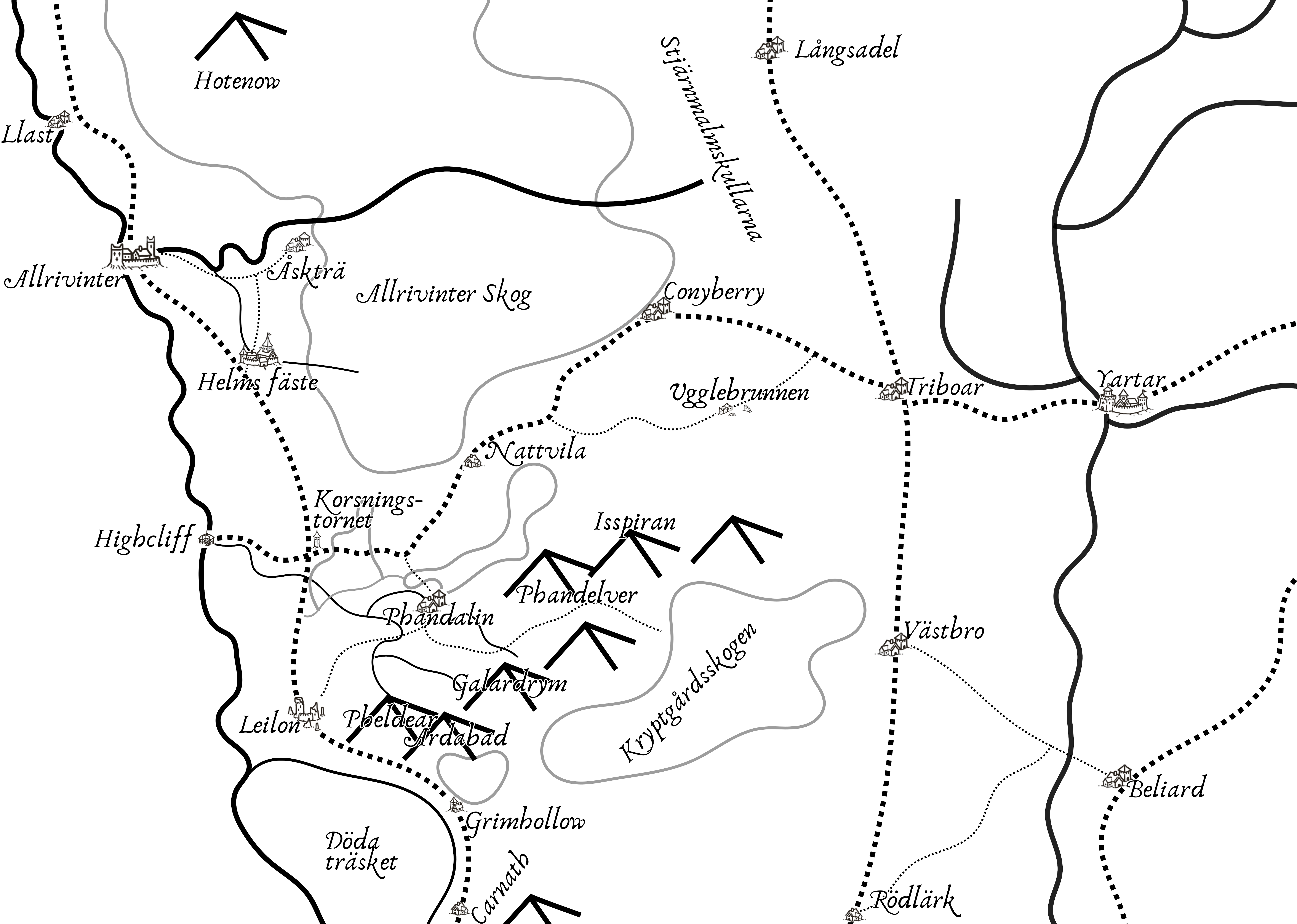
The original inkscape map covers all of Toril but I focused my research around Phandalin. I tried to find everything from Neverwinter city, Neverwinter Wood, Sword Mountains and down to Kryptgarden forest. I used all sources I found for making guesses of how the Phandalin area would look like in more details including smaller paths and streams.
There are a lot of sources out there. Many of them with vague references to the specific locations. Some of the contradictory. I also combined what I found with basic knowledge about geology, rainfall, population, food sources, trade, travel, politics. And I added details for paths and trees based on location descriptions.
Since there should be a lot of places in the region, including farm houses, ruins, caves and more, I took what I found. If there were enough places detailed in the canon sources, I wouldn't add additional places from video games. But for example, there should be some kind of rest stop at least every days travel along the main roads. Crossroad Keep are located in a place where there should be a rest stop, regardless of a canon source or not.
The north is wild and dangerous. But there should still be layers of civilization. Just 10-20 years of peace in a specific region would be enough for young couples to seek out empty places to make new life. And Faerun has thousands of years of history.
The Mere of Dead Men could use more details. The northern parts is actually tidal mudflats. That's why Leilon seems to be away from the coast. But its not obvious as for now where the mudflats ends and the coast cliffs begin. Probably a bit north of Leilon Point.
I moved Dumathoin's Gulch to be nearer Axholm, from the stream going by Phandalin and Highcliff rather than to the Mere of Dead Men. That was the best match I could find based on the local map, distance, direction and layout.
I moved Cragmaw Hideout from north of Triboar Trail to south of the trail since it included a larger cliffside and a lot of water continuously filling up the cave pools. I put a lake on top with water coming from Sword Mountains. Additionally, since both parts of the trail and the hideout is forested, I added a smaller forest along the trail.
I considered adding a trail to the Dread Ring since its a rather large construction with a lot of activity. But I realized that the construction was probably mostly raised from the ground by magic and travel mostly by shadowfell or teleportation.
I added the streams near Phandalin mentioned in the text. A lot of the miners use them for panning for gold and gems. Others follow them further up the mountain to dig in old mines. I also added locations for charcoal and smelting that would have been needed, especially in mining towns.
The result is a sandbox combining adventures from many sources placed in the same region.
I started to set up my own system for delivering the map. But all alternatives I found would take some work to set up for a map that would have to be split up in tiles with different zoom levels. So I settled for exporting everything to easyzoom and entering all the points by hand. Since I can't update the map on easyzoom without losing the annotations, there will be changes in the original file not present in the older exported bitmap. The inkscape file uses the yellow round icons for storing the name of places and the source reference. I also named several forests and other things in the vector objects. The easyzoom version is missing those yellow dots in cases where those places was added after the map export. Since I used a zoomable system I opted to include a larger bit from North-west, but mainly for context.
- Fearun nort-west interactive map with 250+ points of interest
- Original aigan-north-35.svg inkscape file (242 MB)
- Bitmap aigan-north-33-30k.png without labels. 30000 px wide (37 MB)
- Player version of Phandelver region in swedish
[[https://www.facebook.com/aigan/posts/10157610959662393]]
[[https://www.reddit.com/r/dndnext/comments/jchgwh/i_created_this_map_of_250_places_around_phandalin/]]

